
| Weather Data | |||
|---|---|---|---|
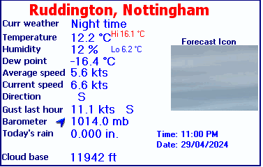
| LAST READING AT TIME: 4:30 AM DATE: 05 February 2025, time of next update: 05:00 AM | |||
| Current Weather | Night time | Current Temperature | 6.8°C (44.2°F), Apparent temp 5.0°C |
| Maximum Temperature (since midnight) | -100.0°C at: 12:49 AM | Minimum Temperature (since midnight) | 100.0°C at: 2:28 AM |
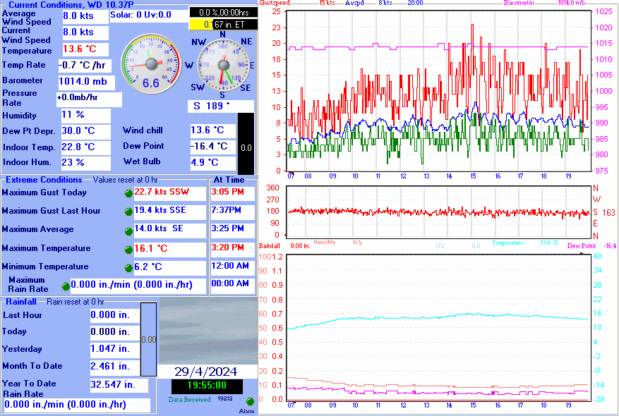
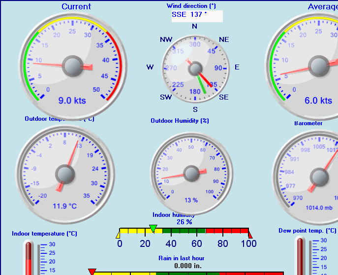
| Average windspeed (ten minute) | 2.0 kts (3.7 kmh) | Wind Direction (ten minute) | SW (225°) |
| Windchill Temperature | 6.7°C | Maximum Gust (last hour) | 0.0 kts (0.0 kmh) at: 4:00 AM |
| Maximum Gust (since midnight) | 0.0 kts (0.0 kmh) at: 12:17 AM | Maximum 1 minute average (since midnight) | 0.0 kts (0.0 kmh) at: 12:04 AM |
| Rainfall (last hour) | 0.000 in. (0.0 mm) | Rainfall (since midnight) | 0.000 in. (0.0 mm) --- |
| Rainfall This month | 0.00 in. (0.0 mm) | Rainfall To date this year | 0.764 in. (19.4 mm) |
| Maximum rain per minute (last hour) | 0.000 in/min | Maximum rain per hour (last 6 hours) | 0.000 in/hour |
| Yesterdays rainfall | 0.000 in | DewPoint | 1.3°C (Wet Bulb :4.6°C ) |
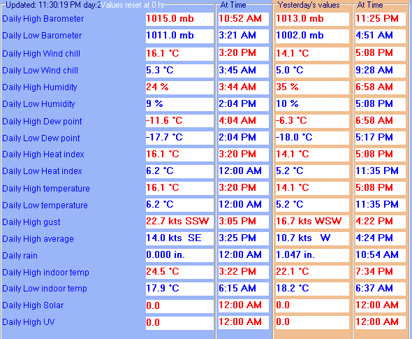
| Humidity | 68 %, Humidex 5.0°C | Barometer corrected to msl | 1021.0 mb |
| Pressure change | 0.0 mb (last hour) | Trend (last hour) | STEADY |
| Pressure change (last 12 hours) | +0.0 mb | Pressure change (last 6 hours) | +0.0 mb |
| Current Indoor Temp. 20.6°C | |||
| Current Indoor Hum. 25% | |||
| Current solar | 0 W/M˛ | Current UV | 0.0 |
| Maximum solar (since midnight) | 0 W/M˛ | Maximum UV (since midnight) | -1.0 |
| Current 00:00 hours of sunshine today, current sky: Night time | |||
| Sunshine hours for the year: | 00:00 hrs | Sunshine hours for the month: | 00:00 hrs |
| Current evapotranspiration 0.02 inches per day. Yesterday's reading 0.03 | |||
Video of the Last Hour
Video of the Last Day
Use the RELOAD facility on your browser to retrieve the latest data.